Despite its name, The Lake District has more mountains than waterways. Although here they aren’t called mountains. They are known as fells, a term used in Scandinavian countries and northern England. Its use to describe the mountains and hills in The Lake District stems from the term once referring to high uncultivated grazing areas. So in this part of the country they have fell running instead of hill running, and fell walking instead of hill walking.
Keswick’s local fell is Skiddaw, which at 931m, is the fourth highest in England. It sits behind the town and from the bottom it doesn’t look that high. It’s a rite of passage for the hostel workers to climb the summit, so with some decent weather forecast on my day off, I figured I’d better give it a go.

There are several routes up Skiddaw, the most popular known appropriately as “The Tourist Track”. One of the guys at the hostel recommended another way up so I decided to try that.
My route, which will eventually take me past Skiddaw House (a remote YHA hostel), starts from Keswick on the same path as The Tourist Track. I’d been warned about Bank Holiday crowds and there were a lot of people about. It was one of the reasons I chose the alternative route. The path starts just behind the town. It’s well marked and in good condition, despite the rain from the previous days. It didn’t take long to get some nice views.

Not long after I took this photo a Kiwi lady and her friend passed me and commented on the view. I noticed her accent and we got chatting as we walked along. They weren’t heading up Skiddaw, but following the same path as me and turning off to head into a valley. We reached the car park from which people can start their walk up Skiddaw or Latrigg, a neighbouring fell of just 368m, but instead of heading through the gate and up the Tourist Track, we headed to the east, along Cumbrian Way, together.
It wasn’t long it started raining and we put on our waterproofs. The track was gravel so it wasn’t too muddy. It did get a bit technical in some parts as the rocks became a bit jagged. In the wet they were very slippery. We got a warning from a mountain biker coming the other way. Even with clouds dropping we still had some nice views. The girls, Nat and Kelso, turned off a little bit after this shot, crossed the river and walked back along the track you can see into the valley.

I got a break from the rain as I neared Skiddaw House, about 3.5miles along the trail. The hostel lies at the junction between several tracks heading over the surrounding fells. I turned to walk up behind the hostel. The track wasn’t prominent, just a path of trodden grass. The rain started again as I headed up the hill and the weather got worse the higher I climber. I went up and over one hill only to eventually see another in front of me. The haze made it impossible to see what was ahead.  The path was more bog than track. The only sounds as I walked up were “squelch, squelch, squelch” and the occasional “baa” from a sheep. Not long after I began wondering where I’d end up if I’d turned off the path by mistake I looked up to see the figures of walkers as my route came to meet the Tourist Track not long before the summit. From here I had a wide gravel path up. After walking alone for the last few miles it was odd to be around so many people.

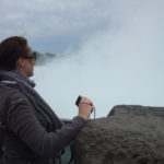
The wind picked up as I got higher and the rain didn’t ease up. The cloud still made it impossible to see what lay ahead so several times I thought I could see the summit, only to see a higher point ahead. Finally I reached the top, although I didn’t hang around long. The weather was awful and the view non-existent so after a quick photo I headed back down.

I stuck to the Tourist Track for the descent and at some stage the rain stopped, although it took me a while to notice after becoming used to it over the last few hours. I found walking the steep downhill jarred my legs a bit so I tended to skip and run where I could. At one stage the clouds lifted slightly to reveal an amazing view of Keswick and Derwentwater, but I didn’t even have time to pull my camera out before the haze dropped again. I kept my camera in my hand in case it happened again, which it did a few minutes later.


This time the clouds kept lifting and the sun shone through – just a little at first but then it started to resemble the day that had been forecast. I almost contemplated heading back up to the summit, but the cloud was still pretty heavy around the top.


 When I reached the car park I decided to make the most of the nicer weather and head up Latrigg. The path from this side is designed for limited mobility so it’s easy going.

 Once at the top, instead of coming back down the same way, I continued over it. Last week I ran past a sign pointing to Skiddaw from the other side of Latrigg so I figured there must be a path down the fell to that point where I could get onto the track I knew. There wasn’t so much a path but again just trodden grass that slightly marked where to go. A trampled through a few more paddocks, again sharing with sheep, and made it to the path, just a few miles from home.

Since the weather was so bad and didn’t make for a good stop at the Skiddaw summit, there’s only one option. I’m going to have to do it again.