Should we or shouldn’t we? A decision that seemed easy, had become agonising. Nothing was in our favour. Not the weather, time or money. It would cost £140 ($250) for a return trip on the ferry. We’d arrive at 2pm, and have to leave at 7.45am. It hardly seemed worth it. So why couldn’t we accept that and drive on?
The Orkney Islands had teased me for a long time. They aren’t as popular or well known as others in Scotland, but looking at the cluster of dots at the top of the map, I was intrigued. I wanted to learn the history, explore those rugged coastlines and hear tales of life in an outpost. A few days at least, maybe a week, was what I needed. Racing between attractions, chased by threatening clouds, was not what danced in my imagination. The experience I craved on Orkney couldn’t be had in an afternoon.
The islands had been on our radar when we started planning the trip along the North Coast 500, but we eventually concluded we didn’t have time to explore properly. Decision made.
Or not.
In the days before arriving at John O’Groats, the islands slipped back into conversations. First a friend in Edinburgh suggested we go there, telling us how much she’d loved her visit. Then a waiter in Inverness, spying our brochures, stopped at our table with one word: “Orkney.”
That’s probably why, despite fog so thick we couldn’t see the edge of the cliffs that ran along the coastline, we drove to the ferry terminal at Gills Bay and the battle between heart and head began.
Both of us tried to get the other to make the call. Reason suggested we skip it. But another feeling tugged at me.
Would this be a case of now or never?
The trip to Orkney was grey. The ferry cruised across Pentland Firth, passing the uninhabited island of Stroma and its abandoned settlements, Nethertown and Uppertown. Through the fog I could see the small houses dotting the otherwise empty landscape. Later, from the windy upper deck we spotted the World war I and II gun batteries at Hoxa Head on South Ronaldsay, and patches of Hoy to the left.
When the ferry docked, dwarfing the small brown houses in the hamlet of St Margaret’s Hope, the skies cleared.
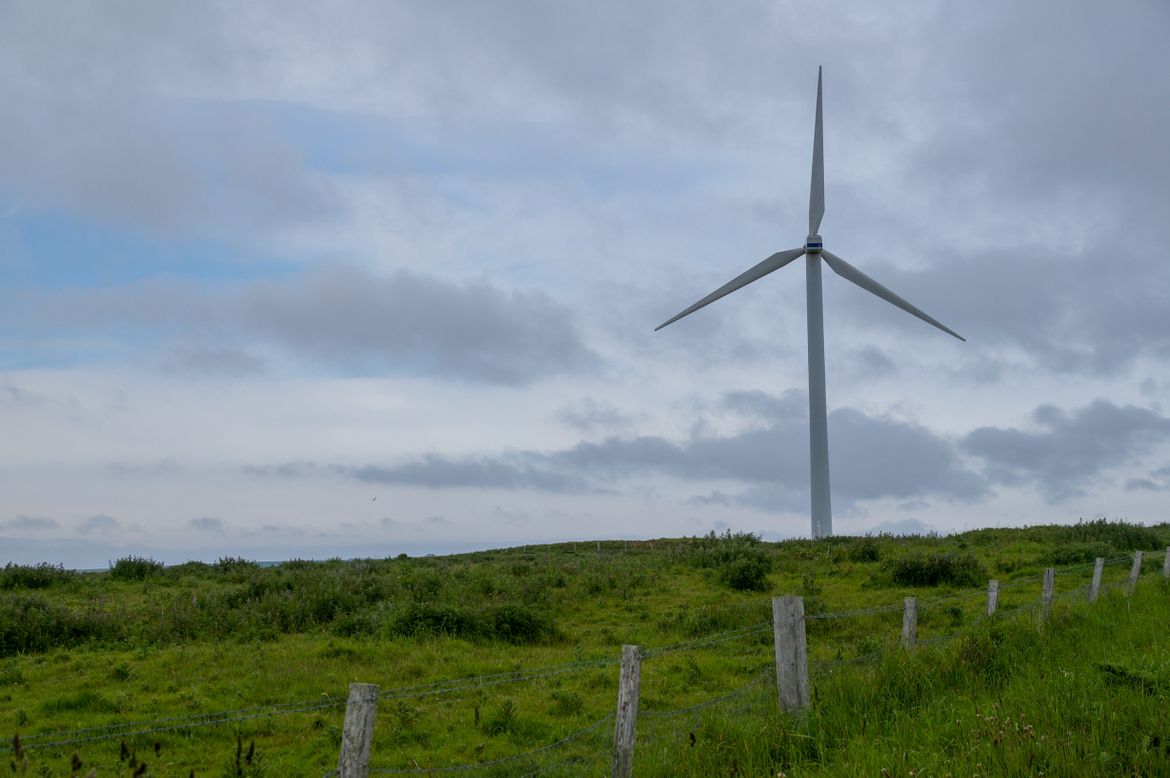
About 70 islands make up this archipelago off the coast of northern Scotland. It has a rich Neolithic history and some sites date back to 3500 BC; four of them comprise the Heart of Neolithic Orkney UNESCO World Heritage Site. Farming and fishing have been big industries here for a long time, but tourism is growing. The wind turbines around the islands reflect another expanding industry. Orkney has become a global leader in renewable energy, having transitioned from a reliance on diesel power.
As we joined the convoy of traffic leaving ‘The Hope’, the islands blurred together. Some were connected by a sliver of land, others by skinny stretches of road exposing those who cross them to buffeting winds. We drove from South Ronaldsay to Burray, past the Italian Chapel on the tiny Lamb Holm, and onto the Mainland; zipping through blink-and-you’ll-miss-it towns, unaware at the time of the history we were passing.
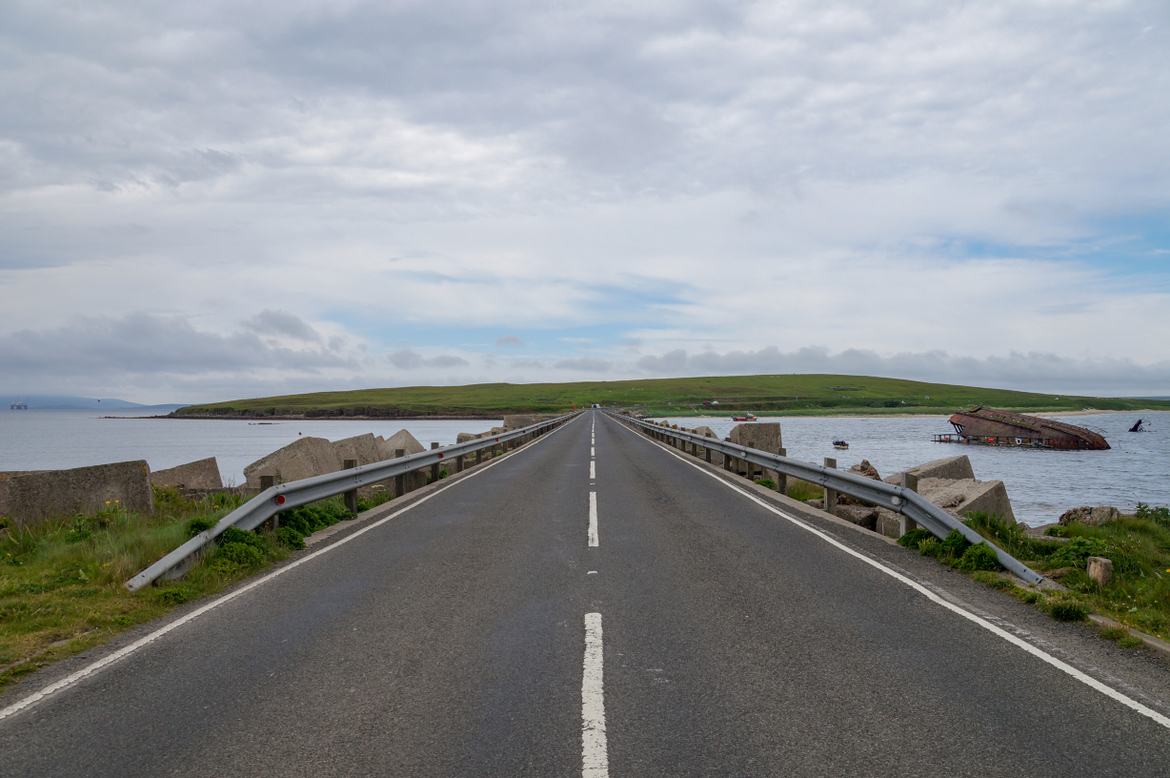
These roads connecting the islands were the Churchill Barriers, built during World War II to prevent ships entering the naval base at Scapa Flow. An earlier strategy to protect the harbour was to sink blockships in the channels, like the SS Reginald, which was sunk in 1915, but is still visible as you travel between Glimps Holm and Burray. Other wrecks have become popular dive sites. But we didn’t know any of that as we headed for Kirkwall, stopping to watch a seal close to shore.
Our run of bad luck, bad timing and bad planning began after leaving Kirkwall, when we found ourselves driving into Stromness 20 minutes later. We had been looking for the turn-off to the Ring of Brodgar, a Neolithic henge and stone circle and one of Orkney’s main attractions. Roads aren’t exactly plentiful here, but somehow we’d missed it.
We parked and left behind the activity of the port as we walked the quiet flagstone streets of Orkney’s second-biggest town. The most interesting view was on the water’s edge.


Narrow paths between the buildings, some barely wide enough for a person, led to the waterfront, where steps and concrete slips fell away into the harbour. A bright red shed, once a lifeboat station and now owned by a local dive business, stood out against grey buildings and dull skies.
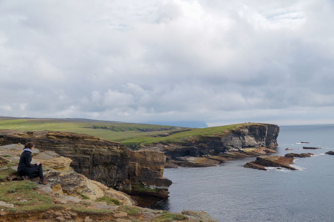
Deserted roads decorated by clusters of red poppies led us to the sandstone cliffs at Yesnaby on the west coast. If we’d had the time we would have hiked the 90-minute coastal walk. Under the threat of rain we headed for Skara Brae, only to be bitten again by poor planning. The site was closing in five minutes and the woman manning the information centre was adamant we couldn’t go in.
No amount of pleading swayed her. She told us curtly that we should have allowed more time; an unnecessary reminder, but it stung.
Every time we admitted how little time we had to spend on Orkney, we were greeted with a knowing, almost tired, expression, but never surprise. I got the impression the locals are used to tourists underestimating their home.
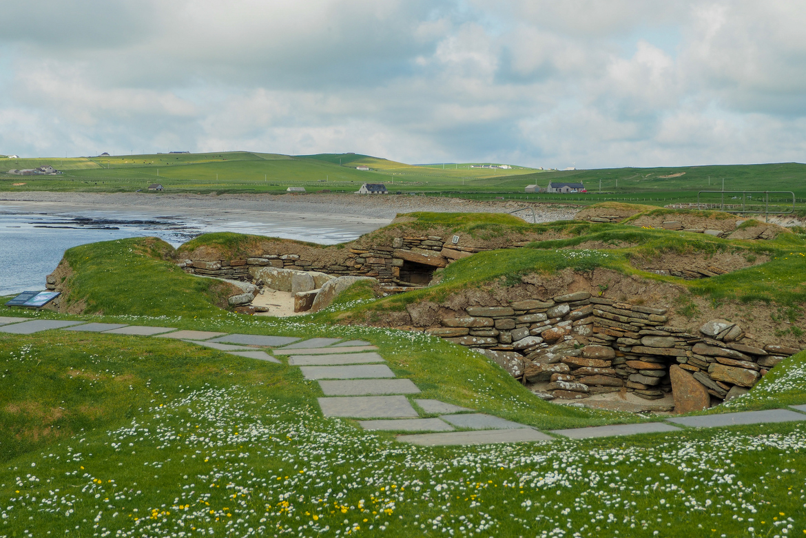
We walked down to the beach, hoping to see something of what is described as the best-preserved Neolithic settlement in Western Europe. The stone village was revealed by a storm in 1850, and is thought to have been inhabited between about 3000 BC and 2000 BC. It’s a glimpse at life in the Stone Age and one of Orkney’s most visited sights. Unfortunately the closest we got was straining over the fence, peering at the top of small sections of the settlement.
• • •
Black clouds chased us from the coast as we began the drive back to South Ronaldsay. We frequently stopped for photos and ducked down side roads just to see a little bit more. Since we’d driven off the ferry, the urge to slow down and take it all in had conflicted with my desire to see as much as possible.
The history of Orkney – from Neolithic periods, to the two World Wars, and the crumbling stone farm buildings that had become scratching posts for cows – had caught my attention and a few hours of frenzied exploration had only stirred my craving to know more.


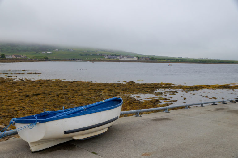
We drove into Finstown under bunting stung between lamp posts, a remnant of jubilee celebrations. As the fog crept over the hills, a crowd of cars and people lined the waterfont, eyes focused across the bay. Intrigued by the activity, and tempted by a fish and chip van, we pulled into the car park.
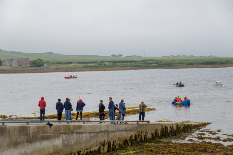
On Friday afternoons, the white Peedie Chippie van sets up shop in the car park by the water at Finstown. On Saturdays it pulls up at Stromness. It’s popular with locals, but this misty summer’s evening had attracted more people than usual to the shore. A raft race, more belated jubilee celebrations, was about to start.
Over a fish supper with mushy peas (of course) and battered pineapple (why not), we watched two teams paddle across the bay in rafts creatively constructed from large plastic drums. The crowd, some in thick winter jackets, others in T-shirts, cheered the winners as the kids splashed through the icy water to pull the raft to shore.
It hadn’t turned out to be the trip I’d imagined when I looked at that cluster of dots at the top of the map. I boarded the ferry at Gills Bay out of curiosity about what was on the other side, but left with even more questions. We hadn’t seen most of Orkney’s main sights and I left with barely a glimpse of its Neolithic wonders.
But of all the moments we pulled together as we flittered around the Mainland, it was eating fish and chips on the shore of the Bay of Firth that stuck with me. In just an hour or so we’d managed what is usually so out of reach on a hurried journey – to get beyond the brochure and enjoy ordinary life in an extraordinary place.